|
|
|||
|
BIG BEND NATIONAL PARK |
|||
|
|
|||
|
Both of the Texas National Parks are in west Texas, within an easy drive of each
other. Towns in the Big Bend National Park Area include Lajitas, Alpine, Study Butte, Marathon and Terlingua, site of the famous Chili Cook-Off, and Marfa, site of the mysterious lights. Big Bend National Park is big, covering 801,163 acres, with great geological contrasts. You can go from the canyons of the Rio Grande with its jungle-like flood plain, up to the Chihuahuan Desert. The desert makes up the majority of the park. |
|||
|
With it various elevations and temperatures, Big Bend National
Park makes for a year round attraction. The Chisos Basin is at 5,400 feet, so it
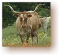
stays a pleasant temperature, even in the hot days of summer. Over 1,200 types of plants can be found in Big Bend National Park. The desert wildlife is mostly nocturnal, but during the day you might see deer, javelinas, coyotes, fox, skunks, raccoons and jackrabbits. A more rare sight would be a black bear, a beaver or the aforementioned mountain lion. |
|
||
|
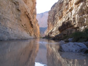
HIKING & BIKING IN BIG BEND Big Bend has more than 200 miles of trails, that range from short, easy walks, to primitive, difficult trails geared to the more experienced hiker. There are more than 100 miles of paved roads and 170 miles of dirt road. Mountain bike riders will find trails to ride in Big Bend National Park. The trailhead for Lost Mine Trail is near Chisos Mountain Lodge. Lost Mine Trail is considered one of the best Big Bend hikes, with moderate elevation gains, a wide range of vegetation and scenic viewpoints. The Lost Mine Trail is 4.8 miles roundtrip. Those not up for that long of a hike, can hike about a mile on the Lost Mine Trail to arrive at what many consider the most incredible view in Big Bend National Park. Rio Grande Village Nature Trail is less than a mile round-trip. That mile starts with a walk on a boardwalk over wetland caused by a natural spring. The boardwalk is followed by a hardscrabble trek over desert with cactus and desert scrub brush. You will come to a viewpoint where you can look across the Rio Grande to the white adobe buildings in the Mexican town of Boquillas. The trailhead to Santa Elena Canyon Trail is a bit difficult to find. Follow a stone path over a shallow creekbed to find the trailhead. You will soon come to a series of switchbacks and steps as you ascend a rocky trail into the canyon. At the end of the trail you will be surrounded by cliffs. You can go swimming in the Rio Grande at this location, one of the few in the park where swimming is permitted. |
|||
|
|
|||
|
BIG BEND DRIVING TOUR The 20 mile drive to Rio Grande Village slowly descends to the Rio Grande River. On the way there you will get the full Chihuahuan Desert experience, with cactus and mesas. BIG BEND PARK SERVICES |
|||
|
|||
|
|
|||
|
Visit
our Eyes on Texas Blog to make a comment |
|||
|
|
|||
|
|
|||
| HOME TEXAS TOWNS PARADES | |||
|
|
|||
| BIG BEND COUNTRY | |||
| GULF COAST PINEY WOODS | |||
| PRAIRIE & LAKES HILL COUNTRY | |||
| SOUTH TEXAS PLAINS | |||
| PANHANDLE PLAINS | |||
|
|
|||
| Del Rio El Paso Fort Davis | |||
| Fort Stockton Langtry Marfa | |||
| Midland Monahans Odessa Pecos | |||
| Sanderson Terlingua Wink | |||
| Guadalupe Mountains National Park | |||
 Texas
is the biggest state, size-wise in the lower 48. Yet Texas only has 2 National
Parks, those being
Texas
is the biggest state, size-wise in the lower 48. Yet Texas only has 2 National
Parks, those being